True Nepal
General Info
Introduction
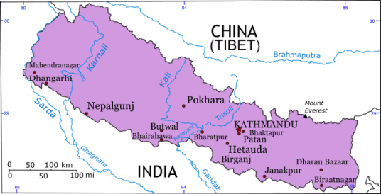
Nepal is a sovereign independent kingdom situated on the southern slopes of the mid-Himalayas, the formidable range of eternal shows. It is located between 26o22' and 30o27' north latitude and 80o4' and 80o12' east longitude.
Total land area is 147,181 square kilometers, and its borders are contiguous with the Indian border in the west, south and east and with Tibetan autonomous region of the People's Republic of China in the north.
Nepal's boundary limits are as follows:
In the east, the Mechi River and Singallia ridge separate the country from Sikkim and West Bengal.
In the south, the boundary pillars and about nine meters of no-man's land on either side demarcate the Nepalese territory from the Indian states of West Bengal, Bihar and Uttar Pradesh.
In the west Mahakali River is the natural border separating the Kingdom from Uttar Pradesh.
Nepal's northern boundary merges with the Tibet Autonomous region of the People's Republic of China. Nepal is a land-locked country, the nearest seacoast being 1,127 kilometers away in India.
Features:
The major part of the country is of high mountains and rolling hills. It accounts for about 83% of the total land and the plain of Terai occupies the remaining 17%. Altitude varies from 152 meters above the sea level in the Terai in the south to 8848 meters in the north Himalayas.
Location:
Nepal is a sovereign independent kingdom situated on the southern slopes of the mid-Himalayas, the formidable range of eternal shows. It is located between 26o22' and 30o27' north latitude and 80o4' and 80o12' east longitude.
Total land area is 147,181 square kilometers, and its borders are contiguous with the Indian border in the west, south and east and with Tibetan autonomous region of the People's Republic of China in the north.
Nepal's boundary limits are as follows:
In the east, the Mechi River and Singallia ridge separate the country from Sikkim and West Bengal.
In the south, the boundary pillars and about nine meters of no-man's land on either side demarcate the Nepalese territory from the Indian states of West Bengal, Bihar and Uttar Pradesh.
In the west Mahakali River is the natural border separating the Kingdom from Uttar Pradesh.
Nepal's northern boundary merges with the Tibet Autonomous region of the People's Republic of China. Nepal is a land-locked country, the nearest seacoast being 1,127 kilometers away in India.
Features:
The major part of the country is of high mountains and rolling hills. It accounts for about 83% of the total land and the plain of Terai occupies the remaining 17%. Altitude varies from 152 meters above the sea level in the Terai in the south to 8848 meters in the north Himalayas.
Physical Features:
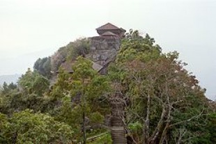
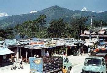
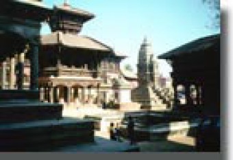
Nepal has four physiographic belts: the Terai plain along the Indian border, the sylvan Churia foothills and the Inner Terai zone to the north, the mid?mountain region, and the Great Himalayan Range. The Terai plain is low in elevation, flat, and fertile, being a northern extension of the Gangetic Plain and is some 26 to 32 km wide. In the south, it is agricultural, and where it joins the foothills, it is marshy and forested. The sparsely populated Churia Hills and the Inner Terai region rise to the rugged Mahabharata Mountain Range, which has elevations of 600-910 m; the intermountain basins are covered with forests. The mid-mountain region, between the Mahabharata Range and the Great Himalayas, has a complex system of ranges between 2,400 and 4,300 m that enclose the Kathmandu and the Pokhara valleys, two flat basins drained by the Baghmati and Seti rivers, respectively. The densely populated Kathmandu valley is the political and cultural hub of the nation. The Great Himalayan Range, from 4,300 to 8,800 m in elevation, contains several of the world's highest peaks-Mt. Everest, Kanchenjunga I, Makalu I, Cho Oyo, Dhaulagiri I, Manaslu I, and Annapurna I-all above 8,040 m. The Kosi, Narayani (Gandak), and Karnali rivers run southward through transverse valleys of the Himalayan chain. They are Nepal's major rivers and have large reserves of hydroelectric power.
Climate:
The climate of Nepal ranges from subtropical monsoon conditions in the Terai region to alpine conditions in the Great Himalayas. Annual rainfall ranges from 70 and 75 inches in the eastern Terai and between 30 and 35 inches in western Nepal. Flooding is a serious problem in the low-lying areas of the Terai plain during the monsoon season, from July to mid-October. The winter season extends from November to March, when temperatures vary from 19�C in the southern Terai region to 13�C in the intermountain basins. During the summer season, which lasts through April and June, the mercury varies from 21�C to 28�C, in the same regions.
Flora and fauna:
There are over 6,500 species of trees, shrubs and wildflowers in Nepal. The height of floral splendor is during the months of March and April when rhododendrons, the national flower, burst into color. Nepal's principal natural resources are the forests, which cover about one-sixth of the country and provide valuable timber, firewood, and medicinal herbs. At the lowest elevations are tropical, humid, deciduous forests that harbor tigers, leopards, deer, monkeys, and a few Indian rhinoceroses. Above 1,200 m, the forests are evergreen and deciduous (oak, maple, magnolia), with occasional leopards and bears on the central Himalayan slopes. Between 3,050 and 3,650 m are coniferous forests with hare, deer, antelope, and small carnivores; above that are sub-alpine and alpine meadows of rhododendron and juniper, harboring musk deer and wild sheep. One can find around 800 different species of bird life in Nepal. HISTORY
Buddhist and Brahmanic Hindu versions of Newar legends dominate the early history of Nepal. The ancient Indian classics contain references to the Nepal valley and lower hill areas. During the 3rd century BC, the emperor of India, Ashoka, supposedly visited Nepal. window.google_render_ad();
In 1769, the Gurkhas led by Prithvi Narayan Shah conquered the Nepal Valley from the Malla dynasty. He moved the capital to Kathmandu, providing the foundation for modern Nepal. From 1775 to 1951, Nepali politics were characterized by conflict between the royal family and several noble families. Often the Shah rulers were relegated to honorary positions, while the political power was concentrated within a dominant noble family.
With support from the Indian government, royal Nepali sovereignty was restored and revolutionary forces gained a position in the administration in the early 1950s. A constitution was approved in 1959, and parliamentary elections were held. Controversy arose between crown and Cabinet in 1960, and King Mahendra dismissed the congress and imprisoned many members. In 1962, a new constitution was promulgated giving the crown greater authority. Though the country was then nominally a constitutional monarchy, the king for many years exercised autocratic control over the country's multi-tiered system of panchayats, or councils, which extended from the village to the national level. The king was able to dominate the Council of Ministers and much of the National Assembly without opposition because political parties were banned under the constitution. In 1972, King Mahendra was succeeded by his son Birendra. In 1990 a series of demonstrations and protests over the king's autocratic rule forced him to lift the ban on political parties and to accept a new cabinet composed largely of opposition political figures. That year a new constitution was also approved that provided for a multiparty democracy and a bicameral parliament.